By Matthew Liebenberg
A local Swift Current landmark had to undergo some repairs to fix damage caused by spring flooding.
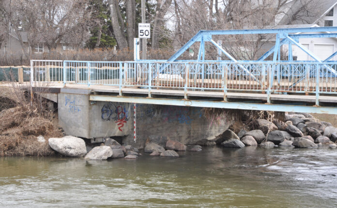
The Lee Lam bridge at Riverside Park on the city’s south side was surrounded by rising water when the creek reached near record levels in April.
The fast-flowing water caused damage to a portion of the structure as well as the adjacent road and pathway.
City General Manager of Infrastructure and Operations Mitch Minken provided details about the damage and repair work done to the bridge at a regular council meeting, June 12.
He noted the fast-running water caused erosion around a support wall for the pedestrian walkway on the east end of the bridge.
“It washed away a lot of the material from a support wall for the pedestrian walkway,” he said. “What we found was that while that support wall for the pedestrian walkway was tied to the actual bridge abutment, there was no piles installed underneath it. It was kind of just supported by the material that it was sitting on. That was fine, especially being tied to the abutment, but we knew that we probably wanted to get some piles in there underneath it to support it.”
The City used an engineering company to assess the situation and it came up with a proposal for the installation of screw piles to support the concrete wall for the pedestrian walkway.
It was the second engineering evaluation of the bridge since the flooding happened and this time the focus was on the repair work to the support wall for the pedestrian walkway. An initial inspection was done by another engineering firm after flood water receded to ensure it was safe to open the bridge for vehicle and pedestrian traffic.
“They inspected it all and even though there was some ice damage done to some of the beams, they passed it for use and that it was structurally sound,” he said. “It’s an older bridge. So it’s definitely reaching towards the end of its life. So at some point or another it may need to be replaced.”
The pedestrian section of the bridge was closed on May 18 for the repair work, but the roadway has remained open for vehicles. The City applied for an emergency aquatic habitat protection permit, which was received on May 31, and the work started on June 5.
The screw piles were installed during the initial week of work. Thereafter the exposed area will be filled up again with concrete and rocky material, known as rip-rap, will be installed on the creek bank to prevent future erosion. Repair work to the damaged sections of the roadway and pathway will also be carried out.
“We had some erosion from the fast-running water over there,” he said. “So we’ve got some pavement to replace on the walkway and on the edge of the roadway, and just some soil mitigation to put some landscaping back in.”
Minken expected all the work to be completed soon. The intention was to re-open the pedestrian walkway before some upcoming events in the community, including the Windscape Kite Festival on June 24 and 25 as well as before the start of Frontier Days on June 28.
The cost of this project will be about $35,000 and the City is hoping it will be covered through the Provincial Disaster Assistance Program (PDAP).
“That’s all part of the application that we’ve made to the province for the PDAP funding,” he said. “So if that is supported by the province, then we may get some reimbursement. If not, that’d be just an emergency repair that we have to take care of.”
The current repair work focused on the side of the bridge where the force of the water caused erosion to the support wall of the pedestrian walkway. Similar damage did not occur on the opposite side.
“There was no damage on that side, because there was no erosion on that side, but we’ll be taking a look at the construction of that side as well,” he said. “If we need to put some piles in there, we will.”
He noted the original grading of the land around the bridge has made a difference to prevent more serious damage to the structure during flood events over the years.
“If you look at some of the drone footage that people took, you’ll see that while the water got to the bottom of the beams of the bridge, it didn’t actually breach the bridge,” he said. “And you’ll see the way that the land around both ends of the bridge is graded, that it actually is designed to let that water run around the bridge rather than top the bridge, which would really do some major damage.”


